As a follow up to my Newsletter Post on June 16th, here is a sample of the material that we (the Society) recently acquired through the purchase of a group of documents that were previously unknown.
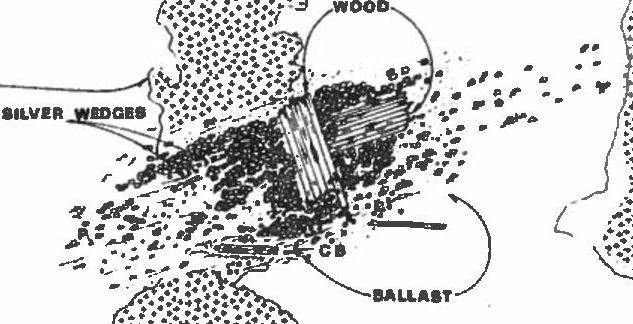
This image is of a site map of the Wedge Wreck (officially, the Urca de LimaSee Wedge Wreck. More) prepared by former State of Florida archaeologist Carl J. Clausen and the late Lou UllianLouis J. (Lou) Ullian (1932 – 2010) Was a diver and original member of the Real Eight Company. A native of Worcester, Massachusetts he served in the U.S. Navy, Naval Weapons Station from 1956 – 19... More, original member of the Real Eight CompanyAlso referred to occasionally as “The Real 8 Company”- was incorporated in 1961. It had eight members….Kip Wagner, Kip Kelso, Dan Thompson, Harry Cannon, Lou Ullian, Del Long, Erv Taylor and Lis... More. We believe this map dates from the mid to late 60’s. The diagram lays out in detail the location of the Wedge WreckA 1715 Fleet wreck site that is located near Fort Pierce Inlet across from Pepper Park. Also referred to as the “Urca de Lima’, the Wedge Wreck is known for silver wedges found on this site by Kip... More together with a survey of the debris field. In the debris field can be seen the position of cannon balls (CB), pottery (P), ballast and most importantly silver wedges (which gave the shipwreck its name).
We have checked around with several authors familiar with Fleet records and documents and were told that this drawing is known to only a handful of people, which makes it somewhat unique. We have also searched several books looking for this image and have not been able to locate a similar drawing anywhere. We have come upon other interesting site maps which we will post in the near future.
Our efforts to organize and inventory our recent recovery is still underway. We will keep everyone updated as we move along.
Ben Costello